The City wants to collaborate with residents and interested and affected parties in the drafting of the local spatial development framework, or neighbourhood plan, for the Kensington and Factreton areas.
Image: City of Cape Town
Kensington Factreton Residents and Ratepayers Association (KFRRA) said they were in agreement with the City's crafting of a Local Spatial Development Framework (LSDF) which will assist in alleviating issues of an overgrown population, informal settlements and traffic congestion.
The City is inviting residents to participate in the crafting of a Local Spatial Development Framework for Kensington and Factreton along the Voortrekker Road Corridor in which stakeholders are invited to submit comments on the draft contextual framework that will form the foundation of the spatial vision.
According to the City, an LSDF determines the development vision for an area on a local level.
Once approved by Council, the City uses the LSDF for guidance when making decisions about development applications and land uses and it will assist in determining how a neighbourhood will function, look and feel a few years down the line.
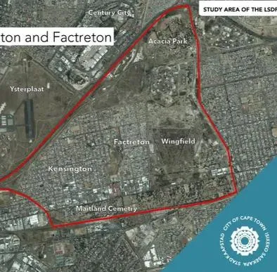
The study area is located along Voortrekker Road and includes Acacia Park and Wingfield, as well as parts of Thornton and the Maitland cemetery.
It added that Kensington and Factreton are facing a range of development challenges, including the growth of informal settlements, land invasions, congestion, and pressure on existing services infrastructure in some areas.
The LSDF-process starts with a contextual framework outlining challenges, needs, constraints, and opportunities. It also includes data on Kensington and Factreton's population, employment, income, environment, heritage, land use, housing, economy, property market, social facilities, movement, and infrastructure.
City’s Deputy Mayor and Mayoral Committee Member for Spatial Planning and Environment, Alderman Eddie Andrews: "Those who live and work in these areas, and own properties have first-hand experience of the unique qualities of their neighbourhoods.
“We want to tap into your knowledge to refine the report so that we can have a more complete understanding of how Kensington and Factreton can be spatially reimagined and revitalised to reach its full potential in coming decades."
The City will answer questions and receive inputs on the LSDF-initiative at an Open Day to be hosted on October 4 at the Kensington Civic Centre in Factreton Avenue.
Kensington Factreton Residents and Ratepayers Association (KFRRA) said they were in agreement with the LSDF: “Given the fact that the Ken-Fac (Kensington and Facreton) community is characterized by many scourges, such as over-congestion, impoverishment, growing informal settlements, population explosions and heavy traffic congestion, the LSDF can be an extremely useful planning tool for not only identifying challenges but also for guiding future spatial development and more importantly at a local level within the broader metropole.”
Cape Argus