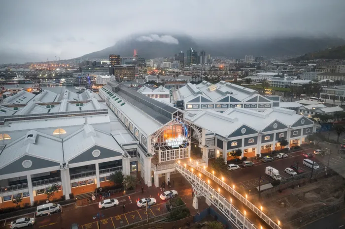
Cape Town’s V&A Waterfront drew 24 million visitors over a year.
Image: Armand Hough / Independent Newspapers
The Mouille Point Ratepayers’ Association (MPRA) supports the V&A Waterfront's rezoning application, acknowledging its economic benefits and job creation as its R20bn redevelopment phases moves from heritage assessment to environmental authorisation.
However, the MPRA said they were concerned about potential increased building heights, negatively affecting views, and additional traffic impacting surrounding suburbs.
They request that these negative impacts, especially traffic, be thoroughly investigated.
The R20 billion project is set to be rolled out over 15 to 20 years and involves reclaiming 3.2 hectares from Table Bay and constructing new mixed-use facilities, including residential, hotel, leisure, and commercial spaces, along with public amenities like a coastal walkway and tidal pools.
The development, proposed by V&A Waterfront Holdings (Pty) Ltd., requires Environmental Authorisation (EA) under NEMA and approval for land reclamation under the Integrated Coastal Management Act (ICMA).
Infinity Environmental (Pty) Ltd. is conducting the Scoping and Environmental Impact Assessment (EIA), with a team of specialists assessing visual, heritage, archaeological, oceanographic, marine, socio-economic, and traffic impacts - all contained in a report.
The report cites key concerns which include potential impacts on heritage resources (like Fort Wynyard and historical shipwrecks) and marine ecosystems (including threatened species like the Heaviside dolphin and African Penguin).
Public participation for the draft Scoping Report began in July and ended on September 1.
The Mouille Point Ratepayers’ Association said while they supported the project they expressed concerns regarding increased bulk, building height, and anticipated traffic.
“The MPRA (Mouille Point Ratepayers’ Association) has reviewed the documents, and visited the Open House, referring to the V&A Rezoning & Permanent Departures Application,” they said in a statement to the Cape Argus.
“We are happy to support this application but wish to note our concern re possible extra bulk, height of buildings (that could negatively affect views of Mouille Point and Green Point residents) as well as the anticipated additional traffic in and through surrounding suburbs due to added infrastructure and population at and visiting the V&A Waterfront.
“For Mouille Point, we would very much like the preferred route to and from the V&A Waterfront not to be through Mouille Point but rather around it via Helen Suzman Boulevard, Granger Bay Boulevard and Portswood Road, which are more direct routes for those on the Atlantic Seaboard. Beach Road Mouille Point should be considered a ‘scenic drive’ rather than a daily ‘rat-race’ route.”
According to a news report shared on the V&A Waterfront’s web page, they are also preparing for the long-term threat of sea-level rise (SLR), which is expected to become more severe by 2050.
Experts highlighted the combination of rising sea levels and more intense storms posing a significant risk.
Alderman Eddie Andrews, the City’s Deputy Mayor and Mayco Member for Spatial Planning and Environment said the rezoning application process was under way.
“The said application is currently being processed by the City and pertains to rezoning. Once finalised, a report on this rezoning application will be submitted to the Municipal Planning Tribunal for consideration,” he stated.
Wouter Kriel, spokesperson for Minister Anton Bredell, Minister of Local Government, Environmental Affairs and Development Planning was also approached for comment and has promised feedback.
Donald Kau, the V&A Waterfront's communications officer, did not respond to queries this week.
Previously Kau confirmed the process had also reached its Heritage Impact Assessment stage last year.
Kau explained the assessment report discussed the heritage significance of the V&A Waterfront and identified several themes which have evolved over time reflecting the Waterfront’s transition from a working harbour to a major tourism destination.
Kau detailed this extended to buildings, infrastructure, possible old shipwrecks to artefacts.
According to the V&A Waterfront’s rich history, in June 1858, winter storms wrecked over 30 vessels.
He further stated that he report concludes the “proposed addition of bulk (for development) to the V&A Waterfront has clearly been guided by urban design principles that are rooted in the heritage significance of the site”.
Some of the key features for planned developments on the Granger Bay site would include: A public walkway linking the city centre to Mouille Point, which would connect with the current Atlantic seaboard promenade, a new Bay area created by coastal protection, suitable for water sports, opening up public access to a new protected area suitable for swimming, with adjoining public amenities.
Cape Argus